January 27, 2014
Men's walking group
How's all the old muscels after that 10 k walk, all okay I hope. We didn't do it as fast as some but we moved along pretty good. I don't think any one walked out of the Bistro hungry. Good day. Next week we will explore the local trail behind the Legion. tks
Men's Walking Group
Great walk today. Weather - normal for Monday Men's Walking Group - perfect. Company - Great. Lunch - also very good. GPS reads 10.5 Km. The following is my view of the walk.
DeNNis.
 |
| Google Earth view of our trek around Beaver and Elk Lakes. |
 |
| Our track superimposed on "Vancouver Island Backroad Maps" |
 |
| It's hard to see the ducks for the trees. |
 |
| SOLITUDE!! |
 |
| Showing off for the girls? |
 |
| Standing on the Dock at the Bay - |
 |
| - putting in time. |
 |
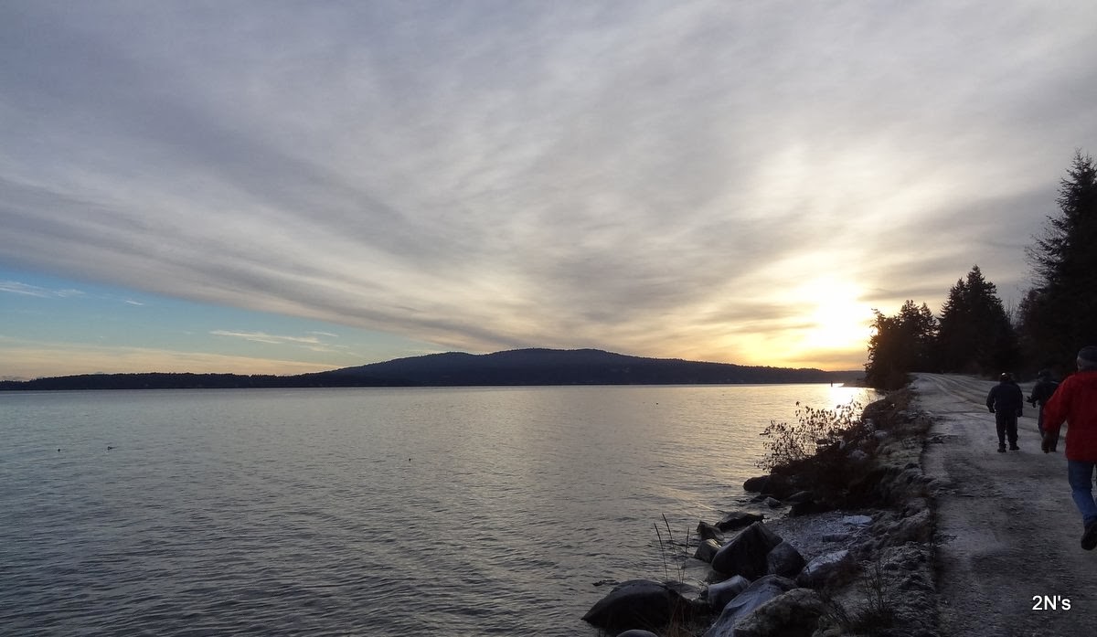
| Looking across Elk Lake from the Dock at the Bay. |
 |
| Looking DOWN to see what is UP. |
 |
| From the north end of Elk Lake - a little mist in the air. |
 |
| Nearing the finish line - still looking pretty chipper! |
January 24, 2014
Womens Walking Group
Nine walked locally on a brisk sunny morning. It was an interesting walk watching a faller take a
large cedar tree down. It was 85 to 100 years old, 120 feet in height. and 4 feet at the base. The faller
is 15 feet from the top when he stops cutting branches and tops it. The tree then comes down in sections and 5 hours later it is all on the ground. He carries rigging lines, a lanyard for extra safety,
and the chainsaw. At times, also water and a lunch. The views are great. Duncan, Mt. Prevost, and
Mt. Baker can be seen. These men do earn their pay. On to the Chippery for our coffee and a treat.
Next week Monday 27th. we will walk through Dean Park. Meeting at the Legion at 10 am. V. M.
January 21, 2014
Men's walking group
We got a little tast of the welderness around us today, Great walk, great weather, Great company. We did about 7 km up an old logging rd from Burnt Bridge. Next week is our day out, Meeting at the Legion at 8:30 and car pooling down to Elk lake for a 10 km walk, Then having lunch at the Bestro on the corner of Inter-erbin & Wilkinson getting back to the Legion by 2 pm.
January 14, 2014
Men's walking group
Good pictures Dennis thank You, To our new walker welcome to our group Brook. I'm sure we live in the best area of the country weather wise. I was hoping for a little more wind down on the beach. ha ha. Good walk.Next week we can try burnt bridge area. Also we plan on doing Elk Lake on the 27th having lunch out, For the new walkers we leave the Legion normal time 8:30 getting back to the Legion by 2:00pm. on our days out. That walk is about 10 km I think.Tks
January 13, 2014
Men's Walking Group
Here is my input from todays walk starting at Manley Park, through to Aros and Telegraph Roads, across the end of the field at Hatch Point Road and back. Great company and, as usual, we lucked out on the weather. - DeNNis.
 |
| The red trace is our route starting at Manley Pk Entrance, down to the Beach and looping around Aros and Telegraph roads. |
 |
| Same trace (blue) as above map. The Chevron Tank Farm is on the right. |

 |
| Down the "Up Staircase" to the beach - then we had to climb up again!!! |
 |
| Fuel barge unloading dock on the right. |
 |
| Looking across to Salt Spring Island. |
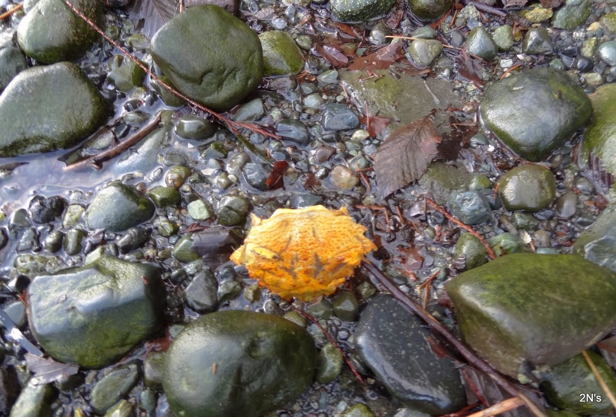 |
| Natures art - empty "Golden" crab shell. |
 |
| Some of the "Old Boys" take a rest at the half-way point. |
 |
| Looking down on the Chevron Tank Farm. |
January 6, 2014
Men's Walking Group
Ten walkers showed up today for a nice jaunt in the crisp, cool (about -1 or -2 degrees) air. My GPS battery shut down enroute - however when it recovered enough for a reading it showed 6.76 Km - and we probably walked another couple of kilometers after that point. Thanks John and John for driving. Stopped and warmed up with coffee afterwards at the little coffee shop/bakery at Shawnigan Village.
We parked in the vehicle parking area along Mill Bay Rd and walked down past the Ferry Terminal to where the new Malahat Cultural Center is being constructed. You can see from the picture of our previous visit that there has been quite a bit of progress since. The solid wood beams make a good impression.
 |
| The dotted blue line shows our route from the parking area down Mill Bay Rd, past the Ferry Terminal, around through Malahat Reserve where the Cultural Center is located and back up Mill Bay Rd. |
 |
| This is a photo from our last visit - Dec. 2nd - 2013. |
 |
| A beautiful brisk day for a walk along the water. |
 |
| Notice the peeled logs used for uprights and the solid wood beams. The "mobiles" (a little hard to make out in this photo) are at the far end of the structure and will probably be unrecognizable when the center is complete. |
 |
| A different view. The "mobiles" are under the covering. |
 |
| This is the plaque on the water fountain/trough in the photo below. |
 |
| This water fountain/trough can be seen on Mill Bay Rd a little before you arrive at the Ferry Terminal. |
 |
| A panoramic view from Mill Bay Road. |
January 1, 2014
YSAGS at the Shawnigan Shiver
To all a HAPPY NEW YEAR!
Here are some pictures from the First Annual Shawnigan Shiver held on January 1, 2014. Over 100 brave souls went into the 3.5C degrees water and some stayed in for 5 minutes.
YSAGS did their part to make this a great event. Anybody recognize the clowns? You might even spot an occasional YSAGS member in the crowd.


 Ed
Ed
Here are some pictures from the First Annual Shawnigan Shiver held on January 1, 2014. Over 100 brave souls went into the 3.5C degrees water and some stayed in for 5 minutes.
YSAGS did their part to make this a great event. Anybody recognize the clowns? You might even spot an occasional YSAGS member in the crowd.


Subscribe to:
Posts (Atom)